 Sponge measures
Sponge measures aim to absorb, store, and slowly release water through landscapes.
Sponge measures mitigate floods and droughts and strengthen ecosystems against climate change, biodiversity loss, and pollution.
Their implementation requires robust scientific evidence, which is challenging due to limited historical data, the need for diverse expertise, particularly in ecology, hydrology and soil sciences and long-term cooperation between stakeholders.
This is precisely where SpongeScapes aims to help, by bringing new evidence and tools for upscaling the implementation of sponge measures in landscape wide sponge strategies.
 Sponge strategies
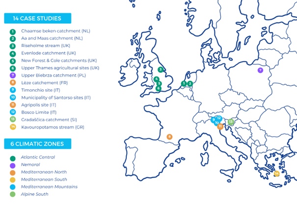
14 Case Studies and 2 SpongeLabs to assess sponge measures and co-design sponge strategies at landscape scale
SpongeScapes aim is to upscale individual 'sponge measures' into overarching 'sponge strategies' at the landscape scale. To do this, we combine detailed monitoring of individual measures with landscape-scale modelling approaches to determine the maximum sponge capacity of catchments under current and future change scenarios. Throughout the project, we will involve stakeholders in the co-design and implementation of sponge measures in different geographical landscapes, taking into account co-benefits and trade-offs.
 FAQ
FAQ
Curious about our work? Read our FAQ to learn more about some key research concepts derived from ecology, hydrology, soil science and computer science.
-
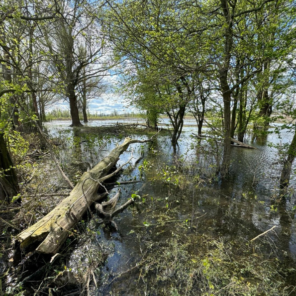
Urbanization, river engineering and intensive agriculture have damaged landscapes ' natural sponge functions. In less urbanized landscapes, rainwater is slowed down by a variety of "natural barriers": trees and vegetation, hedges, ditches, wetlands. The water then slowly circulates through the landscape, feeding a variety of streams and their floodplains. It can also better infiltrate the soil, replenishing the groundwater table. Sponge measures aim to improve an environment's ability to absorb, store, and slowly release water over a long period of time, often supporting dry season flows . They are inspired by how natural ecosystems function. They can include planting vegetation, restoring rivers and wetlands, or changing farming practices. Sponge measures help the water cycle find its natural, slower rhythm so that it can better support natural ecosystems, sustain economic activities and increase our resilience to extreme events such as floods or droughts.
-
In SpongeScapes our motto is "green where we can, grey where we must" because we believe that humans are also part of the landscape. This may result in hybrid approaches at landscape scale, where green and grey are jointly used to reach an overarching goal. In heavily modified landscape even "green" sponge measures may need additional artificial infrastructures to function (e.g. a weir that influences water levels in streams and influences the groundwater levels in the surrounding area). Also, a single "green" sponge measure (hedges, stream or wetland restoration), like a single "grey" sponge measure (dam or weir, large drain), may not be sufficient to stop a flood on its own, it has to be part of a holistic plan. This is why often a combination of green and grey measures is necessary, always bearing in mind that today's challenges require us to take better account of natural ecosystems and protect them as much as possible.
-
The “Sponge City” concept focusses on urban areas: the aim is to design cities like giant sponges, so that water stays in the city for as long as possible and drains away safely, making them more resilient to flooding and storing water in green spaces to make them more resilient to heat waves. In this perspective sponge measures are in line with the concepts underlying Sponge Cities. In 2014, the People's Republic of China launched the Sponge City concept to address urban surface water flooding and related urban water management issues. In these areas, recent extreme events have shown that even a landscape perspective may not fully protect the city from flooding: in extreme weather events, sponge measures can only be one part in the cities' overarching integrated flood protection strategies, where other measures such as early warning, zoning and building codes should also be included. In SpongeScapes, we aim to apply the “sponge” concept at a sufficiently large spatial scale, including rural and peri-urban areas, in a coherent landscape and/or watershed approach.
-
Sponge measures, natural water retention measures (NWRM), nature-based solutions (NBS) and green infrastructure are all related to sustainable environmental management, but originally focused on different aspects. Today, these concepts are sometimes used interchangeably to highlight the importance of healthy ecosystems for the sustainability of human societies. These different concepts reflect the need for specialists to better define this new field of activity and also to better define the expected impact of the measures implemented. For example, sponge measures and Natural Water Retention Measures (NWRM) are specific to water management and aim to mimic natural water cycle processes. Green infrastructure integrates natural elements into urban design, providing ecological services such as stormwater management and recreational spaces. Nature-based solutions are broader, addressing a range of environmental issues including climate change mitigation and biodiversity.
-
We refer to landscapes as "an area, as perceived by people, whose character is the result of the action and interaction of natural and/or human factors ”. The landscape scale is particularly important for the development of sponge strategies as it is a useful scale to investigate hydrological and ecological processes (the landscape water cycle) as well as to co-design strategies appropriate to a specific biophysical and governance context. Administrative boundaries often do not align with biophysical boundaries, for example with watersheds. The whole catchment scale is often too large for appropriate place and context-specific solution strategies. Or a municipality may be located on an area that partially covers one or more catchments.
-
Monitoring sponge measure helps in assessing their effectiveness in absorbing, storing and slowly releasing water. Ideally monitoring should begin years before the sponge measure is installed so as to be able to evaluate their success. Data gathered includes the rate of water absorption, storage capacity, impact on reducing surface runoff and flooding and overall effectiveness in different climatic and geographical conditions. Monitoring also helps to understand other co-benefits (and potential unintended consequences early so as to manage them), such as ecological benefits (supporting biodiversity and improving soil quality) and, ultimately, the functions of nature on which we all depend. This is essential to inform and improve future management and planning strategies.
-
A model is a formal representation of the behaviour of system processes, often in mathematical or statistical terms on a computer, that can be used to simulate what might happen in the real system. In SpongeScapes, we use modelling to simulate how Sponge measures and their combination work in different environmental and climate scenarios. The aim is to help predict the effectiveness of one or more sponge measures, such as absorption rates, storage capacity, etc. By simulating different conditions (different vegetation, climate, soil types, slope, ...) we aim to support decision making and optimise the design and implementation of sponge measures. In SpongeScapes, we use modelling to demonstrate our hypothesis that the integration of several sponge measures across a landscape creates a cumulative sponge effect that benefits flood protection - without preventing it altogether - and drought resilience, and provides many other benefits (biodiversity, etc.)
 Case Studies
SpongeScapes builds upon 14 case studies and revisits 140 recorded cases of sponge measures to monitor their performance under different types of hydrometeorological events (droughts, floods, etc). They are both rural and peri-urban case studies and include four different sponge measure categories (surface water, groundwater, soils and mixed) in different climatic zones and diverse soils (sandy, silty, clayey, peaty, calcareous).